
Freeze Warnings and Fire Risks Grip North Coast as Unpredictable Weather Patterns Persist
Residents of California’s North Coast are bracing for a weather whiplash, as the region faces a mix of freeze warnings, frost advisories, and high fire risk warnings. According to Edward Swafford, a lead meteorologist at the National Weather Service in Eureka, a freeze warning has been issued for several areas, including Trinity, Southern Humboldt, interior northern Trinity, Southern Trinity, and Mendocino.
“We’re looking at possible frost and freeze looking like Trinity, and it’ll be from 1am to 10am on Friday,” Swafford said. “The freeze one will be for subfreezing temperatures as low as 30. So, we’re advising people to pull in their pets, you know, and also for crop sake, you want to take mitigating circumstances to alleviate your crop kill or whatever sensitive vegetation that you have, you’ll need to take actions for.”
In addition to the freeze warning, a frost advisory has been issued for southern Mendocino coast [and] interior, Boonville, Hopland, and Calpella – Philo areas, from 1am to 10am on Friday. “It’s not as bad as obviously a freeze, but the frost advisory will be for those areas,” Swafford explained.
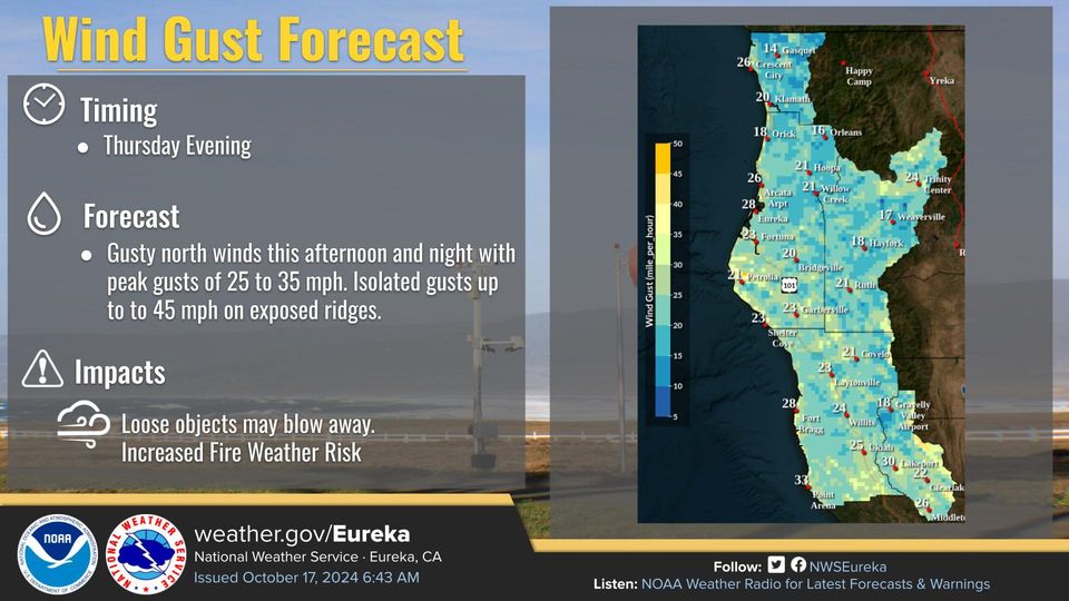
The weather concerns don’t stop there. Lake County has been issued a red flag warning, which will go into effect tonight at 11pm and last through Saturday. “The major fire concern is for Lake County, and what’s going on is we have strong offshore winds, really low humidity, and the fuels that we’re concerned with are extremely dry,” Swafford said. “This is usually the time of the year that we have …really serious fire events that happen.”
Swafford attributed the high fire risk to a combination of meteorological factors, including a low-pressure system moving from Oregon and a high-pressure system offshore, which creates an “adverse kind of wind event.” While the region may see some light rain on Monday, Swafford acknowledged the difficulty in predicting precipitation amounts due to the lack of moisture in the atmosphere and the transitional nature of the weather patterns. “We’re definitely getting into cooler times, but it’s going to be a bit unsettled as far as temperature goes, because Tuesday warms up a little bit again. And then looking at Wednesday, Wednesday warms back up,” he said.
Despite the cooler temperatures, the burn ban remains in effect due to the persistent fire risk.